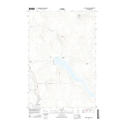
2014 Map of Scopan Lake West
USGS Topo · Published 2014About this map
Scopan Lake dominates the central landscape of this Aroostook County survey, which documents the rural and industrial infrastructure of the northern Maine woods. The settlement of Masardis sits at the confluence of the Aroostook River and Saint Croix Stream, serving as a focal point for the region's transport network. The presence of Nowland Siding and Midway Siding along the rail corridor indicates the historical importance of timber or freight transport in these remote townships. Elevated terrain features like Sterling Ridge, Nowland Hill, and Brushy Hill frame the drainage basins of Clayton Brook and Nowland Brook. Local history researchers will find the Smith Cem near the river, while the small settlement of Scopan is situated near the outlet of Scopan Stream.
Find a feature on this map
24 named features on this map. Tap any name to fly to it.
Don’t see what you’re looking for? This feature index may not catch every label — zoom into the map to look around manually.
Map Details
Editions of this 2014 Scopan Lake West Map
This is the sole edition of this map. No revisions or reprints were ever made.
Other maps of this area

1931 · Ashland
USGS Topo · 1:48,000

1934 · Ashland
USGS Topo · 1:62,500

1935 · Howe Brook
USGS Topo · 1:48,000

1935 · Presque Isle
USGS Topo · 1:62,500

1939 · Howe Brook
USGS Topo · 1:62,500

1940 · Oxbow
USGS Topo · 1:62,500

1942 · Oxbow
USGS Topo · 1:62,500

1953 · Ashland
USGS Topo · 1:62,500

1953 · Presque Isle
USGS Topo · 1:62,500

1954 · Howe Brook
USGS Topo · 1:62,500