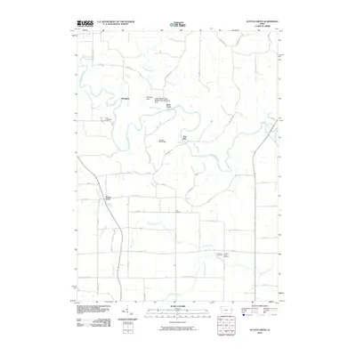
2010 Map of Scotch Grove
USGS Topo · Published 2010About this map
The Maquoketa River winds through this Jones County landscape, creating a series of deep loops that define the local geography north of Scotch Grove. This 2010 survey highlights a transition from the agricultural plateaus to the river's more complex corridors, where landmarks like Chimney Rock and Dales Ford mark the shoreline. The legacy of early industry remains visible along the water, evidenced by Ebys Mill and the nearby Corbett's Mill Bridge.
Find a feature on this map
45 named features on this map. Tap any name to fly to it.
Don’t see what you’re looking for? This feature index may not catch every label — zoom into the map to look around manually.
Map Details
Editions of this 2010 Scotch Grove Map
This is the sole edition of this map. No revisions or reprints were ever made.
Other maps of this area

1891 · Monticello
USGS Topo · 1:62,500

1891 · Baldwin
USGS Topo · 1:62,500

1900 · Anamosa
USGS Topo · 1:125,000

1901 · Peosta
USGS Topo · 1:125,000

1959 · Dubuque
USGS Topo · 1:250,000

1961 · Dubuque
USGS Topo · 1:250,000

1962 · Dubuque
USGS Topo · 1:250,000
1966 · Fillmore
USGS Topo · 1:24,000

1966 · Hopkinton East
USGS Topo · 1:24,000
1966 · Cascade
USGS Topo · 1:24,000