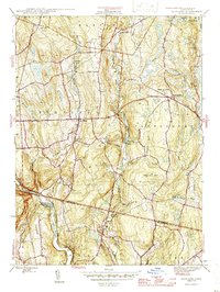
1946 Map of Scotland
USGS Topo · Published 1946About this map
Merrick Brook and the Little River define the agricultural and wooded landscape of this eastern Connecticut region during the mid-1940s. The settlement of Scotland serves as a central hub, surrounded by smaller communities like Westminster and Hanover. The map reveals a deeply rooted rural history through several family-named burial grounds, including the Bradford Cem and Raymond Cem, while the Howard Valley Ch stands as a local landmark.
Find a feature on this map
35 named features on this map. Tap any name to fly to it.
Don’t see what you’re looking for? This feature index may not catch every label — zoom into the map to look around manually.
Map Details
Editions of this 1946 Scotland Map
This is the sole edition of this map. No revisions or reprints were ever made.
Other maps of this area

1889 · Putnam
USGS Topo · 1:62,500

1889 · Moosup
USGS Topo · 1:62,500

1892 · Woodstock
USGS Topo · 1:62,500

1892 · Norwich
USGS Topo · 1:62,500

1893 · Putnam
USGS Topo · 1:62,500

1893 · Moosup
USGS Topo · 1:62,500

1919 · Putnam
USGS Topo · 1:62,500

1920 · Moosup
USGS Topo · 1:62,500

1921 · Woodstock
USGS Topo · 1:62,500

1943 · Plainfield
USGS Topo · 1:31,680