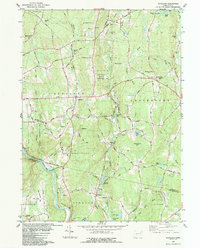
1983 Map of Scotland
USGS Topo · Published 1984About this map
Pudding Hill and the surrounding highlands of eastern Connecticut define this landscape in the early 1980s, where rural hamlets remain connected by a network of winding roads like Ziegler Road and Westminster Road. The settlement of Scotland serves as a central point, with local history preserved in family-named sites such as Raymond Coffey Cem and the Howard Valley Ch. To the south, the Shetucket River valley marks the transition into New London Co, where industry and infrastructure appear near the Hanover village, including the Hanover Reservoir and Industrial Waste Ponds. The presence of several large protected areas, including Beaver Brook State Park and Mohegan State Forest, indicates a region where significant tracts of wooded hills were maintained alongside established farming and residential properties.
Find a feature on this map
93 named features on this map. Tap any name to fly to it.
Don’t see what you’re looking for? This feature index may not catch every label — zoom into the map to look around manually.
Map Details
Editions of this 1983 Scotland Map
This is the sole edition of this map. No revisions or reprints were ever made.
Other maps of this area

1889 · Putnam
USGS Topo · 1:62,500

1889 · Moosup
USGS Topo · 1:62,500

1892 · Woodstock
USGS Topo · 1:62,500

1892 · Norwich
USGS Topo · 1:62,500

1893 · Putnam
USGS Topo · 1:62,500

1893 · Moosup
USGS Topo · 1:62,500

1919 · Putnam
USGS Topo · 1:62,500

1920 · Moosup
USGS Topo · 1:62,500

1921 · Woodstock
USGS Topo · 1:62,500

1943 · Plainfield
USGS Topo · 1:31,680