1943 Map of Scottsville
USGS Topo · Published 1969About this map
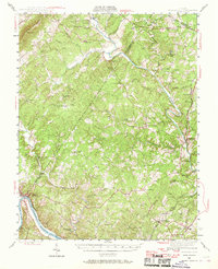
The Rivanna River and James River frame this landscape at the intersection of Albemarle and Fluvanna counties, illustrating a region defined by its historic estates and rural crossroads. Landmarks like Ash Lawn and Blenheim appear alongside the agricultural and social infrastructure of the mid-20th century, including the Jefferson Mill and Woodside Sch. The importance of river-based transport and industry is evident near Union Mills and along the Chesapeake and Ohio railway, which follows the James River shoreline through Shores and Paynes.
Find a feature on this map
70 named features on this map. Tap any name to fly to it.
Don’t see what you’re looking for? This feature index may not catch every label — zoom into the map to look around manually.
Map Details
Editions of this 1943 Scottsville Map
This is the sole edition of this map. No revisions or reprints were ever made.
Other maps of this area

1891 · Palmyra
USGS Topo · 1:125,000

1892 · Buckingham
USGS Topo · 1:125,000

1892 · Gordonsville
USGS Topo · 1:125,000

1892 · Harrisonburg
USGS Topo · 1:125,000

1895 · Palmyra
USGS Topo · 1:125,000

1897 · Palmyra
USGS Topo · 1:125,000

1929 · Covesville
USGS Topo · 1:62,500

1931 · University
USGS Topo · 1:62,500

1935 · Charlottesville
USGS Topo · 1:62,500

1935 · Charlottesville And Vicinity
USGS Topo · 1:31,680