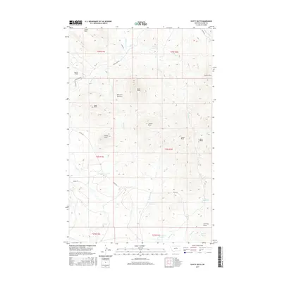
2017 Map of Scotty Butte
USGS Topo · Published 2017About this map
The Bears Paw Mountains define the northern Montana landscape of this quadrangle, where a series of prominent peaks and plateaus rise above the high plains. Named elevations including Scotty Butte, Black Butte, and Thunder Butte dominate the horizon, serving as crucial landmarks for navigation and local history. The drainage patterns of Peoples Cr and Rieve Cr dictate the layout of the land, while several water management features such as Rieve Reservoir and Upper Hansen Reservoir indicate the region's agricultural and pastoral infrastructure. In the southeastern corner, the label for Coal Mine Coulee points toward a history of local resource extraction. A sparse network of rural routes, including Birdtail Rd and Peoples Creek Rd, connects these remote points, reflecting the expansive and isolated nature of the terrain.
Find a feature on this map
38 named features on this map. Tap any name to fly to it.
Don’t see what you’re looking for? This feature index may not catch every label — zoom into the map to look around manually.
Map Details
Editions of this 2017 Scotty Butte Map
This is the sole edition of this map. No revisions or reprints were ever made.
Other maps of this area

1953 · Havre
USGS Topo · 1:250,000

1956 · Maddux
USGS Topo · 1:62,500

1956 · Rattlesnake
USGS Topo · 1:62,500

1956 · Lloyd
USGS Topo · 1:62,500

1956 · Cleveland
USGS Topo · 1:62,500

1957 · Havre
USGS Topo · 1:250,000

1958 · Havre
USGS Topo · 1:250,000
1987 · Cleveland
USGS Topo · 1:24,000
1987 · Runyan Bench
USGS Topo · 1:24,000
1987 · Miles Butte
USGS Topo · 1:24,000