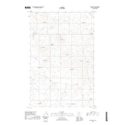
2020 Map of Scotty Butte
USGS Topo · Published 2020About this map
The Bears Paw Mountains define this high-plains landscape in Blaine County, where numerous prominent peaks and isolated buttes rise sharply from the surrounding terrain. Notable summits such as Black Butte, Taylor Butte, Johnson Butte, and the namesake Scotty Butte punctuate the horizon, serving as ancient landmarks for travelers and ranching operations. The area’s hydrology is characterized by a network of seasonal drainages, including Peoples Creek and Suction Creek, which feed into several local water catchments. Reservoirs like the Rieve Reservoir, Upper Hansen Reservoir, and Lower Hansen Reservoir indicate the vital importance of water management in this arid region. Traces of historical land use appear in names like Coal Mine Coulee, hinting at early resource extraction, while a modest network of local routes like Birdtail Road and Peoples Creek Road provide access through the complex topography of ridges and coulees.
Find a feature on this map
39 named features on this map. Tap any name to fly to it.
Don’t see what you’re looking for? This feature index may not catch every label — zoom into the map to look around manually.
Map Details
Editions of this 2020 Scotty Butte Map
This is the sole edition of this map. No revisions or reprints were ever made.
Other maps of this area

1953 · Havre
USGS Topo · 1:250,000

1956 · Maddux
USGS Topo · 1:62,500

1956 · Rattlesnake
USGS Topo · 1:62,500

1956 · Lloyd
USGS Topo · 1:62,500

1956 · Cleveland
USGS Topo · 1:62,500

1957 · Havre
USGS Topo · 1:250,000

1958 · Havre
USGS Topo · 1:250,000
1987 · Cleveland
USGS Topo · 1:24,000
1987 · Runyan Bench
USGS Topo · 1:24,000
1987 · Miles Butte
USGS Topo · 1:24,000