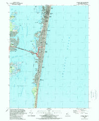
1989 Map of Seaside Park
USGS Topo · Published 1989About this map
The dense coastal developments of Lavallette, Seaside Heights, and Seaside Park dominate the narrow barrier island separating Barnegat Bay from the Atlantic Ocean. This late 1980s survey illustrates a landscape defined by seasonal recreation and maritime navigation, where the Intra-coastal Waterway threads through the bay's complex network of sedge islands and thoroughfares. The transition from the developed borough grids to the preserved environment of Island Beach Sand Dunes State Park at the southern end of the sheet reveals the contrast between the Jersey Shore's built environment and its natural coastal ecology.
Find a feature on this map
48 named features on this map. Tap any name to fly to it.
Don’t see what you’re looking for? This feature index may not catch every label — zoom into the map to look around manually.
Map Details
Editions of this 1989 Seaside Park Map
2 editions found
Other maps of this area

1888 · Barnegat
USGS Topo · 1:62,500

1888 · Asbury Park
USGS Topo · 1:62,500

1893 · Asbury Park
USGS Topo · 1:62,500

1893 · Barnegat
USGS Topo · 1:62,500

1898 · Barnegat
USGS Topo · 1:62,500

1901 · Asbury Park
USGS Topo · 1:62,500

1902 · Navesink
USGS Topo · 1:125,000

1919 · Barnegat
USGS Topo · 1:62,500

1919 · Asbury Park
USGS Topo · 1:62,500

1941 · Toms River
USGS Topo · 1:62,500