1894 Map of Seattle
USGS Topo · Published 1908About this map
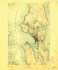
The Seattle waterfront of the late 19th century reveals an emerging urban center still intimately tied to its maritime and riverine landscape. While the street grid is already dense between Elliott Bay and Lake Union, the Dwamish River remains a sinuous, meandering waterway before its channelization, surrounded by small settlements like South Park, Dwamish, and Vanasselt. This period captures the city before the completion of the Lake Washington Ship Canal; Salmon Bay is not yet connected to Lake Union, and Shilshole Bay marks the primary opening to the sound. To the north, Ballard and Fremont appear as distinct hubs, while the shoreline of Lake Washington is dotted with landing points such as Yesler, Pontiac, and Brighton Beach, all linked by rail lines like the Seattle Lake Shore and Eastern R.R.
Find a feature on this map
69 named features on this map. Tap any name to fly to it.
Don’t see what you’re looking for? This feature index may not catch every label — zoom into the map to look around manually.
Map Details
Editions of this 1894 Seattle Map
2 editions found
Other maps of this area

1894 · Seattle
USGS Topo · 1:62,500

1895 · Snohomish
USGS Topo · 1:125,000

1897 · Tacoma
USGS Topo · 1:125,000

1897 · Seattle
USGS Topo · 1:125,000

1900 · Tacoma
USGS Topo · 1:125,000

1908 · Seattle
USGS Topo · 1:62,500

1909 · Seattle Special
USGS Topo · 1:62,500

1937 · Port Orchard
USGS Topo · 1:62,500

1937 · Port Gamble
USGS Topo · 1:62,500

1940 · Port Gamble
USGS Topo · 1:62,500