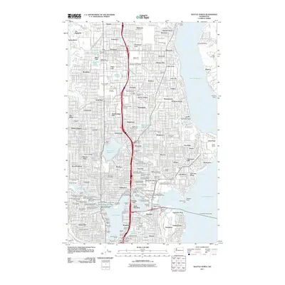
2011 Map of Seattle North
USGS Topo · Published 2011About this map
University of Washington anchors the central landscape of this northern urban corridor, situated between the waters of Union Bay and Portage Bay. The 2011 survey reveals a dense network of neighborhoods and academic institutions, including Seattle Pacific University and Bastyr University. A significant concentration of historical interment sites, such as Washelli Cemetery, Evergreen Park Cemetery, and Lake View Cemetery, provides a wealth of data for local history and genealogical research.
Find a feature on this map
139 named features on this map. Tap any name to fly to it.
Don’t see what you’re looking for? This feature index may not catch every label — zoom into the map to look around manually.
Map Details
Editions of this 2011 Seattle North Map
This is the sole edition of this map. No revisions or reprints were ever made.
Other maps of this area

1894 · Seattle
USGS Topo · 1:62,500

1895 · Snohomish
USGS Topo · 1:125,000

1897 · Seattle
USGS Topo · 1:125,000

1908 · Seattle
USGS Topo · 1:62,500

1909 · Seattle Special
USGS Topo · 1:62,500

1942 · Edmonds
USGS Topo · 1:62,500

1944 · Everett
USGS Topo · 1:62,500

1949 · Shilshole Bay
USGS Topo · 1:24,000
1949 · Duwamish Head
USGS Topo · 1:24,000

1949 · Seattle North
USGS Topo · 1:24,000