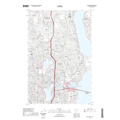
2020 Map of Seattle North
USGS Topo · Published 2020About this map
Seattle's northern neighborhoods and the city of Shoreline are depicted here in detail, showcasing the complex maritime geography of the Lake Washington Ship Canal and its connection to Salmon Bay. The landscape is dominated by dense residential districts like Wallingford, Fremont, and Greenwood, structured around the expansive campuses of the University of Washington and North Seattle College. Large green spaces and commemorative sites occupy significant acreage, including the Evergreen Washelli Cem and the Grand Army of the Republic Cem near Broadway. Significant engineering works facilitate transit across the city's waterways, notably the George Washington Memorial Bridge and the Governor Albert D. Rosellini Bridge-Evergreen Point, which spans Lake Washington to the east.
Find a feature on this map
81 named features on this map. Tap any name to fly to it.
Don’t see what you’re looking for? This feature index may not catch every label — zoom into the map to look around manually.
Map Details
Editions of this 2020 Seattle North Map
This is the sole edition of this map. No revisions or reprints were ever made.
Other maps of this area

1894 · Seattle
USGS Topo · 1:62,500

1895 · Snohomish
USGS Topo · 1:125,000

1897 · Seattle
USGS Topo · 1:125,000

1908 · Seattle
USGS Topo · 1:62,500

1909 · Seattle Special
USGS Topo · 1:62,500

1942 · Edmonds
USGS Topo · 1:62,500

1944 · Everett
USGS Topo · 1:62,500

1949 · Shilshole Bay
USGS Topo · 1:24,000
1949 · Duwamish Head
USGS Topo · 1:24,000

1949 · Seattle North
USGS Topo · 1:24,000