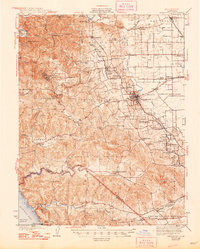
1942 Map of Sebastopol
USGS Topo · Published 1948About this map
Sebastopol serves as the central hub of this Sonoma County landscape, surrounded by a productive agricultural interior and coastal reaches. The map highlights the region's dense network of early 20th-century rural infrastructure, from the Northwestern Pacific RR line connecting towns like Graton and Forestville to the numerous local schoolhouses such as Gold Ridge Sch and Pleasant Hill Sch that dotted the countryside. The geography shifts from the flat Llano de Santa Rosa in the east to the more varied terrain of the west, where landmarks like Bohemian Grove and Joy Woods Redwood Grove mark the timbered hills. Near the coast, the Estero Americano winds toward Bodega Bay, defining the boundary between Sonoma and Marin counties. This survey captures a moment when the "Apple Capital" was deeply interconnected by rail and road, showing named corners like Sousa Corners and Knowles Corner that anchored the local farming community.
Find a feature on this map
104 named features on this map. Tap any name to fly to it.
Don’t see what you’re looking for? This feature index may not catch every label — zoom into the map to look around manually.
Map Details
Editions of this 1942 Sebastopol Map
3 editions found

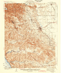
Other maps of this area

1914 · Petaluma
USGS Topo · 1:62,500

1916 · Santa Rosa
USGS Topo · 1:62,500

1916 · Point Reyes
USGS Topo · 1:48,000

1918 · Point Reyes
USGS Topo · 1:62,500

1920 · Healdsburg
USGS Topo · 1:62,500

1921 · Skaggs
USGS Topo · 1:62,500

1927 · Calistoga
USGS Topo · 1:62,500

1933 · Healdsburg
USGS Topo · 1:48,000

1935 · Sebastopol
USGS Topo · 1:48,000

1940 · Healdsburg
USGS Topo · 1:62,500