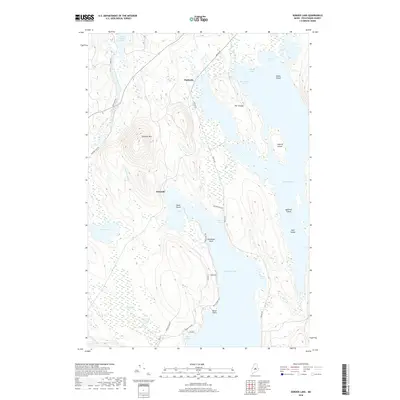
2018 Map of Seboeis Lake
USGS Topo · Published 2018About this map
Seboeis Lake and Schoodic Lake dominate this portion of Piscataquis County, where a network of water and timber roads defines the landscape. Small settlements at Packards and Schoodic sit along the western shores and rail corridors, while the terrain rises sharply at Schoodic Mtn. The hydrology of the region is intricate, connecting Upper Ebeemee Lake to the south via the East Branch Pleasant River and Schoodic Stream. Local history is embedded in the nomenclature of the many islands and coves, including Dollar Island, Leyford Island, and Dean Island, as well as distinctive landmarks like Deadman Rock. Traces of the region's industrial past are visible in the alignment of the Old Wagner RR, which cuts through the timberland between the major lakes. From the expanse of Orson Bog to the high points of The Tongue, this 2018 survey provides an exact record of the recreational and working forests of central Maine.
Find a feature on this map
37 named features on this map. Tap any name to fly to it.
Don’t see what you’re looking for? This feature index may not catch every label — zoom into the map to look around manually.
Map Details
Editions of this 2018 Seboeis Lake Map
This is the sole edition of this map. No revisions or reprints were ever made.
Other maps of this area

1940 · Sebec
USGS Topo · 1:48,000

1943 · Sebec
USGS Topo · 1:62,500

1947 · Schoodic
USGS Topo · 1:62,500

1949 · Schoodic
USGS Topo · 1:62,500

1951 · Norcross
USGS Topo · 1:62,500

1952 · Jo-Mary Mountain
USGS Topo · 1:62,500

1954 · Millinocket
USGS Topo · 1:250,000

1958 · Millinocket
USGS Topo · 1:250,000

1960 · Millinocket
USGS Topo · 1:250,000
1978 · Brownville Junction
USGS Topo · 1:24,000