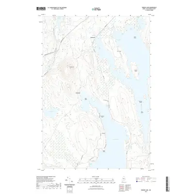
2021 Map of Seboeis Lake
USGS Topo · Published 2021About this map
Packards and the small settlement of Schoodic are nestled in a landscape defined by the expansive waters of Seboeis Lake and Schoodic Lake in Piscataquis County. This 2021 survey illustrates the complex aquatic and woodland geography of central Maine, dominated by the prominent elevation of Schoodic Mtn. The transport network of the era is a mix of specialized logging and access roads like Horseback Millinocket Rd and Trestle Rd, which reflect the region's industrial and recreational utility. A significant historical marker is found in the traces of the Old Wagner RR near Italian Cove. The map also captures numerous smaller water bodies and wetlands, including West Pond and the extensive Orson Bog, as well as named landmarks like Deadman Rock and Birch Point, providing a detailed record of the shoreline's character before further modernization.
Find a feature on this map
39 named features on this map. Tap any name to fly to it.
Don’t see what you’re looking for? This feature index may not catch every label — zoom into the map to look around manually.
Map Details
Editions of this 2021 Seboeis Lake Map
This is the sole edition of this map. No revisions or reprints were ever made.
Other maps of this area

1940 · Sebec
USGS Topo · 1:48,000

1943 · Sebec
USGS Topo · 1:62,500

1947 · Schoodic
USGS Topo · 1:62,500

1949 · Schoodic
USGS Topo · 1:62,500

1951 · Norcross
USGS Topo · 1:62,500

1952 · Jo-Mary Mountain
USGS Topo · 1:62,500

1954 · Millinocket
USGS Topo · 1:250,000

1958 · Millinocket
USGS Topo · 1:250,000

1960 · Millinocket
USGS Topo · 1:250,000
1978 · Brownville Junction
USGS Topo · 1:24,000