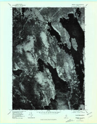
1978 Map of Seboeis Lake
USGS Topo · Published 1981About this map
Seboeis Lake and Schoodic Lake dominate this orthophotoquad, which captures the lake-strewn landscape of central Maine in the late 1970s. The map illustrates a region defined by extensive water bodies and dense forest, where human settlement is clustered at small outposts like Packards and Schoodic. Unlike traditional topographic maps, this aerial imagery provides a direct look at the texture of the timberland and the complex, irregular shorelines of Ebee Mee Lake. The elevation of Schoodic Mountain rises between the major basins, serving as a prominent landmark in a territory primarily accessed by narrow tracks and water. This record is particularly valuable for documenting the precise footprint of lakeside structures and logging roads as they existed before modern development altered these shorelines.
Find a feature on this map
6 named features on this map. Tap any name to fly to it.
Don’t see what you’re looking for? This feature index may not catch every label — zoom into the map to look around manually.
Map Details
Editions of this 1978 Seboeis Lake Map
This is the sole edition of this map. No revisions or reprints were ever made.
Other maps of this area

1940 · Sebec
USGS Topo · 1:48,000

1943 · Sebec
USGS Topo · 1:62,500

1947 · Schoodic
USGS Topo · 1:62,500

1949 · Schoodic
USGS Topo · 1:62,500

1951 · Norcross
USGS Topo · 1:62,500

1952 · Jo-Mary Mountain
USGS Topo · 1:62,500

1954 · Millinocket
USGS Topo · 1:250,000

1958 · Millinocket
USGS Topo · 1:250,000

1960 · Millinocket
USGS Topo · 1:250,000
1978 · Brownville Junction
USGS Topo · 1:24,000