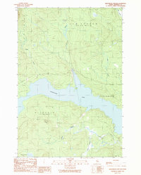
1989 Map of Seboomook Lake East
USGS Topo · Published 1989About this map
Seboomook Lake dominates this northern Maine landscape, serving as a central drainage point for a complex network of streams and brooks during the late 1980s. The map illustrates a region defined by commercial timber management and hydrological flow, where the North Branch and South Branch converge near the southern shore. The terrain is marked by significant elevations like Sevenmile Hill and the presence of specialized forest infrastructure, indicated by numerous Private logging roads that snake through the townships of Plymouth and Elm Stream. Waterways such as Nulhedus Stream and Negro Brook feed into the lake, while the remote Socatean Ponds sit at the southwestern edge. This provisional survey captures the intersection of industrial land use and the wild character of the North Woods, including small-scale extraction sites like a Gravel Pit near the northern boundary.
Find a feature on this map
15 named features on this map. Tap any name to fly to it.
Don’t see what you’re looking for? This feature index may not catch every label — zoom into the map to look around manually.
Map Details
Editions of this 1989 Seboomook Lake East Map
This is the sole edition of this map. No revisions or reprints were ever made.
Other maps of this area

1954 · Seboomook Lake
USGS Topo · 1:62,500

1954 · North East Carry
USGS Topo · 1:62,500

1954 · Caucomgomoc Lake
USGS Topo · 1:62,500

1954 · St. John Pond
USGS Topo · 1:62,500

1954 · Presque Isle
USGS Topo · 1:250,000

1954 · Millinocket
USGS Topo · 1:250,000

1958 · Presque Isle
USGS Topo · 1:250,000

1958 · Millinocket
USGS Topo · 1:250,000

1958 · Caucomgomoc Lake
USGS Topo · 1:62,500

1958 · Saint John Pond
USGS Topo · 1:62,500