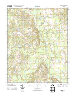
2013 Map of Sebrell
USGS Topo · Published 2013About this map
The Nottoway River defines the central topography of this Southampton County landscape, its meandering course punctuated by several named crossings that reveal the area's local transport network. The small settlement of Sebrell sits near the eastern edge, connected to the surrounding countryside by roads such as Barn Tavern Rd and Carys Bridge Rd. The terrain is significantly defined by its wetlands, with extensive features like Hunting Quarter Swamp, Buckhorn Swamp, and Hornet Swamp draining into the river system. These low-lying areas, along with tributaries like Raccoon Cr and Three Cr, have historically dictated the placement of farms and timber tracks. Bridges such as Peters Bridge, Westbrook Bridge, and Crichton Bridge serve as vital landmarks for understanding the local geography and historical movement through this heavily watered landscape.
Find a feature on this map
41 named features on this map. Tap any name to fly to it.
Don’t see what you’re looking for? This feature index may not catch every label — zoom into the map to look around manually.
Map Details
Editions of this 2013 Sebrell Map
This is the sole edition of this map. No revisions or reprints were ever made.
Other maps of this area

1919 · Jarratt
USGS Topo · 1:62,500

1919 · Homeville
USGS Topo · 1:48,000

1919 · Boykins
USGS Topo · 1:48,000

1919 · Arringdale
USGS Topo · 1:48,000

1920 · Homeville
USGS Topo · 1:62,500

1920 · Boykins
USGS Topo · 1:62,500

1920 · Arringdale
USGS Topo · 1:62,500

1942 · Arringdale
USGS Topo · 1:62,500

1943 · Sebrell
USGS Topo · 1:31,680

1943 · Manry
USGS Topo · 1:31,680