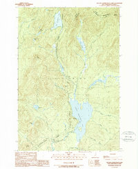
1989 Map of Second Connecticut Lake
USGS Topo · Published 1989About this map
Second Connecticut Lake and the northernmost headwaters of the Connecticut River dominate this remote landscape along the international border in the late 1980s. The map details the transition from the secluded Fourth Connecticut Lake through Third Connecticut Lake, surrounded by the protected lands of the Connecticut Lakes State Forest. The settlement of Idlewild sits on the western shore of the second lake, serving as a rare point of human habitation in a region defined by extensive water systems like the East Inlet Flowage and Scott Bog. The terrain is marked by significant elevations including Salmon Mountain and Deer Mtn, which frame narrow valleys such as West Desmond Valley. Numerous family-named landmarks like Emery Allen Brook and Smith Brook provide valuable clues for genealogists tracking early presence in this northern corner of Pittsburg.
Find a feature on this map
32 named features on this map. Tap any name to fly to it.
Don’t see what you’re looking for? This feature index may not catch every label — zoom into the map to look around manually.
Map Details
Editions of this 1989 Second Connecticut Lake Map
This is the sole edition of this map. No revisions or reprints were ever made.
Other maps of this area

1925 · Indian Stream
USGS Topo · 1:48,000

1926 · Indian Stream
USGS Topo · 1:62,500

1927 · Indian Stream
USGS Topo · 1:62,500

1927 · Moose Bog
USGS Topo · 1:48,000

1927 · Second Lake
USGS Topo · 1:62,500

1931 · Moose Bog
USGS Topo · 1:62,500

1932 · Second Lake
USGS Topo · 1:62,500

1949 · Jackman
USGS Topo · 1:250,000

1963 · Jackman
USGS Topo · 1:250,000

1966 · Sherbrooke
USGS Topo · 1:250,000