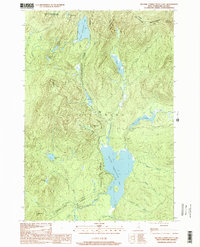
1997 Map of Second Connecticut Lake
USGS Topo · Published 2000About this map
The headwaters of the Connecticut River dominate this remote northern landscape, where the international boundary between the United States and Canada defines the northern edge of the terrain. The map traces the river's origin through a chain of high-elevation water bodies, starting at the Fourth Connecticut Lake within the Fourth Connecticut Lake State Preserve and descending through the Third Connecticut Lake and Second Connecticut Lake. This area of Pittsburg, New Hampshire, is largely defined by the Connecticut Lakes State Forest, with small clusters of development like Idlewild on the western shore of the largest lake. The topographic detail captures the intricate drainage system of the North Country, including the East Inlet Flowage, Scott Bog, and numerous brooks like Moose Brook and Robie Brook that feed into the Connecticut valley from the surrounding peaks of Salmon Mountain and Deer Mtn.
Find a feature on this map
32 named features on this map. Tap any name to fly to it.
Don’t see what you’re looking for? This feature index may not catch every label — zoom into the map to look around manually.
Map Details
Editions of this 1997 Second Connecticut Lake Map
This is the sole edition of this map. No revisions or reprints were ever made.
Other maps of this area

1925 · Indian Stream
USGS Topo · 1:48,000

1926 · Indian Stream
USGS Topo · 1:62,500

1927 · Indian Stream
USGS Topo · 1:62,500

1927 · Moose Bog
USGS Topo · 1:48,000

1927 · Second Lake
USGS Topo · 1:62,500

1931 · Moose Bog
USGS Topo · 1:62,500

1932 · Second Lake
USGS Topo · 1:62,500

1949 · Jackman
USGS Topo · 1:250,000

1963 · Jackman
USGS Topo · 1:250,000

1966 · Sherbrooke
USGS Topo · 1:250,000