1960 Map of Sedgwick
USGS Topo · Published 1960About this map
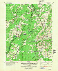
The Cache River and its complex network of sloughs and ditches dominate this 1960 study of the Arkansas lowlands, where Lawrence, Greene, and Craighead Counties meet. The landscape is defined by the efforts to manage water for agriculture, evident in features like the Lost Creek Ditch and Gum Slough. Small settlements such as Sedgwick, Bono, and Egypt serve as hubs for the surrounding farming communities, connected by the St Louis Southwestern and St Louis San Francisco railroads. This era shows a densely settled rural interior marked by numerous community centers like Egypt Sch and Little Brown Ch. Genealogists will find a wealth of family history in the various rural burial grounds, including Manning Cem, Arnold Cem, and Gibson Cem, many of which sit on slightly higher ground like Hickory Ridge above the river bottomlands.
Find a feature on this map
59 named features on this map. Tap any name to fly to it.
Don’t see what you’re looking for? This feature index may not catch every label — zoom into the map to look around manually.
Map Details
Editions of this 1960 Sedgwick Map
This is the sole edition of this map. No revisions or reprints were ever made.
Historical Maps of Jonesboro Through Time
3 maps found