Loading...
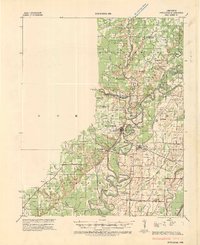
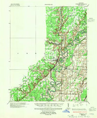
Loading map...1934 Map of Powhatan
USGS Topo · Published 1934About this map
Black River meanders through this portion of Lawrence County and Randolph County, defining a landscape of oxbow lakes and wetlands. The settlement at Powhatan sits near the river’s edge, serves as a focal point alongside Black Rock and Portia. The map captures a complex system of river crossings, including Gibson Ferry, Scotts Ferry, and Cox Ferry, illustrating the reliance on water transport before the extensive expansion of U S Hy No 62.
Find a feature on this map
88 named features on this map. Tap any name to fly to it.
Don’t see what you’re looking for? This feature index may not catch every label — zoom into the map to look around manually.
Map Details
Date Portrayed1934
Date Published1934
PublisherU.S. Geological Survey
Map TypeTopographic
Scale1:62,500
Physical Dimensions17.62 x 21.63 inches
Editions of this 1934 Powhatan Map
This is the sole edition of this map. No revisions or reprints were ever made.
Historical Maps of Hoxie Through Time
Featured Locations
Source Details
SourceU.S. Geological Survey
CopyrightPublic Domain