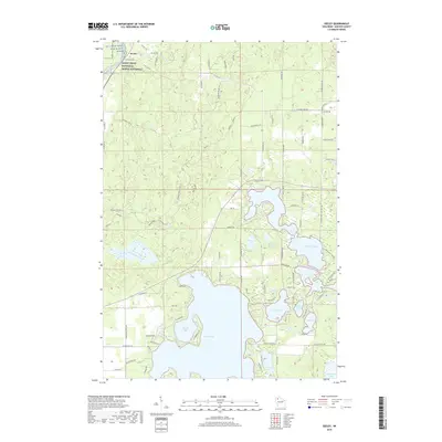
2019 Map of Seeley
USGS Topo · Published 2019About this map
The unincorporated community of Seeley serves as the focal point for this section of Sawyer County, positioned along the banks of the St. Croix Wild and Scenic River. This area is defined by the protected corridor of the Saint Croix National Scenic Riverway, which preserves the river's character as it flows near Riverside Cem. The landscape to the south and east transitions into a complex glacial topography dominated by a dense network of lakes and bays. Round Lake and its northern reach at Hinton Bay provide a significant shoreline, while smaller basins like McClaine Lake, Lake Placid, and Mirror Lake are interconnected by local roads such as Wheel Inn Dr and Scheller Rd. This survey captures a mix of residential development around the lakefronts and vast tracts of undeveloped terrain accessed by forest routes like Thannum Fire Ln and the Mosquito Brook Fire Ln.
Find a feature on this map
86 named features on this map. Tap any name to fly to it.
Don’t see what you’re looking for? This feature index may not catch every label — zoom into the map to look around manually.
Map Details
Editions of this 2019 Seeley Map
This is the sole edition of this map. No revisions or reprints were ever made.
Other maps of this area

1943 · Namekagon Lake
USGS Topo · 1:48,000

1944 · Couderay
USGS Topo · 1:48,000

1944 · Radisson
USGS Topo · 1:48,000

1944 · Hayward
USGS Topo · 1:48,000

1945 · Namekagon Lake
USGS Topo · 1:48,000

1948 · Couderay
USGS Topo · 1:48,000

1949 · Radisson
USGS Topo · 1:48,000

1953 · Ashland
USGS Topo · 1:250,000

1953 · Rice Lake
USGS Topo · 1:250,000

1958 · Ashland
USGS Topo · 1:250,000