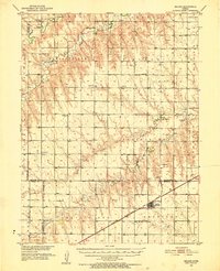
1951 Map of Selden
USGS Topo · Published 1952About this map
The Chicago Rock Island and Pacific railroad cuts through the southern reaches of this Kansas landscape, anchoring the town of Selden as a focal point of commerce and transit in the early 1950s. The surrounding High Plains terrain is defined by the branching drainage of Sappa Creek to the north and Dog Prairie Creek to the south. This survey reveals a remarkably dense network of rural infrastructure, pointing to a well-distributed agrarian population that supported numerous country schools like Plainview Sch and O Toole Sch.
Find a feature on this map
39 named features on this map. Tap any name to fly to it.
Don’t see what you’re looking for? This feature index may not catch every label — zoom into the map to look around manually.
Map Details
Editions of this 1951 Selden Map
2 editions found
Other maps of this area

1951 · Selden
USGS Topo · 1:62,500

1951 · Herndon
USGS Topo · 1:62,500

1951 · Achilles
USGS Topo · 1:62,500

1951 · Oberlin
USGS Topo · 1:62,500

1951 · Kanona
USGS Topo · 1:62,500

1954 · Goodland
USGS Topo · 1:250,000

1956 · Goodland
USGS Topo · 1:250,000

1957 · Goodland
USGS Topo · 1:250,000

1965 · Oberlin
USGS Topo · 1:24,000

1965 · Kanona
USGS Topo · 1:24,000