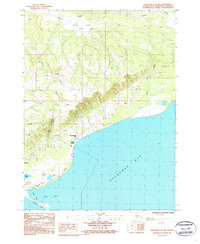
1987 Map of Seldovia C-4 NW
USGS Topo · Published 1987About this map
Homer and the surrounding coastline of the Kenai Peninsula are captured in the late 1980s, documenting a landscape where residential expansion meets rugged natural features. The town’s relationship with Kachemak Bay is central, with development concentrated along the northern shore and the iconic Homer Spit extending into the water. Settlement patterns at this time show clusters of activity at Kachemak City and Millers Landing, connected by roads like Skyline Drive that follow the contours of the high ground above the bay.
Find a feature on this map
26 named features on this map. Tap any name to fly to it.
Don’t see what you’re looking for? This feature index may not catch every label — zoom into the map to look around manually.
Map Details
Editions of this 1987 Seldovia C-4 NW Map
This is the sole edition of this map. No revisions or reprints were ever made.
Other maps of this area

1946 · Seldovia C-5
USGS Topo · 1:63,360

1946 · Seldovia D-5
USGS Topo · 1:63,360

1948 · Seldovia C-4
USGS Topo · 1:63,360

1949 · Seldovia C-4
USGS Topo · 1:62,500

1949 · Seldovia D-4
USGS Topo · 1:63,360

1951 · Seldovia C-5
USGS Topo · 1:63,360

1951 · Seldovia D-5
USGS Topo · 1:63,360

1951 · Seldovia D-4
USGS Topo · 1:63,360

1951 · Seldovia
USGS Topo · 1:250,000

1961 · Seldovia C-5
USGS Topo · 1:63,360