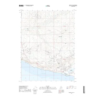
2018 Map of Seldovia C-5 NE
USGS Topo · Published 2018About this map
Homer sits at the southern edge of this survey, where the rugged terrain of the Kenai Peninsula meets the Pacific Ocean. This modern-era topographic study reveals the extensive residential road network climbing the slopes above the coast, including high-elevation settlements like Diamond Ridge and Woodard Canyon. The coastal geography is defined by Bluff Point to the west and the marshy environments of Beluga Slough and Beluga Lake near the town center. Local institutions and landmarks are well-documented, from the Kenai Peninsula College- Kachemak Bay Campus to the Homer Community Cem and Hickerson Memorial Cem. Numerous watercourses such as the Anchor River and Bridge Cr drain the high ridges, including Ohlson Mtn and Crossman Ridge, illustrating the complex drainage patterns of this coastal landscape.
Find a feature on this map
105 named features on this map. Tap any name to fly to it.
Don’t see what you’re looking for? This feature index may not catch every label — zoom into the map to look around manually.
Map Details
Editions of this 2018 Seldovia C-5 NE Map
This is the sole edition of this map. No revisions or reprints were ever made.
Other maps of this area

1946 · Seldovia C-5
USGS Topo · 1:63,360

1946 · Seldovia D-5
USGS Topo · 1:63,360

1948 · Seldovia C-4
USGS Topo · 1:63,360

1949 · Seldovia C-4
USGS Topo · 1:62,500

1949 · Seldovia D-4
USGS Topo · 1:63,360

1951 · Seldovia C-5
USGS Topo · 1:63,360

1951 · Seldovia D-5
USGS Topo · 1:63,360

1951 · Seldovia D-4
USGS Topo · 1:63,360

1951 · Seldovia
USGS Topo · 1:250,000

1961 · Seldovia C-5
USGS Topo · 1:63,360