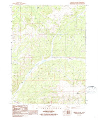
1987 Map of Seldovia D-4 SW
USGS Topo · Published 1987About this map
The Anchor River carves a deep path through the southern Kenai Peninsula in this 1980s provisional survey, which highlights the area's transition from high alpine tundra to riparian lowlands. To the north, Stariski Creek drains the upland reaches, while Bald Mountain dominates the southeastern corner of the quadrangle. Human presence is sparse but specific, indicated by a lone Landing Strip in the northeast and a Winter Trail cutting through the western terrain near Beaver Creek. This map is particularly valuable for its depiction of the landscape before significant modern development, showing the original drainage patterns and elevation profiles of the peninsula's interior. The provisional nature of the survey reflects a time when many Alaskian interior regions were being systematically documented from 1980s aerial photography and field checks.
Find a feature on this map
6 named features on this map. Tap any name to fly to it.
Don’t see what you’re looking for? This feature index may not catch every label — zoom into the map to look around manually.
Map Details
Editions of this 1987 Seldovia D-4 SW Map
This is the sole edition of this map. No revisions or reprints were ever made.
Other maps of this area

1946 · Seldovia C-5
USGS Topo · 1:63,360

1946 · Seldovia D-5
USGS Topo · 1:63,360

1948 · Seldovia C-4
USGS Topo · 1:63,360

1949 · Seldovia C-4
USGS Topo · 1:62,500

1949 · Seldovia D-4
USGS Topo · 1:63,360

1951 · Seldovia C-5
USGS Topo · 1:63,360

1951 · Seldovia D-5
USGS Topo · 1:63,360

1951 · Seldovia D-4
USGS Topo · 1:63,360

1951 · Seldovia
USGS Topo · 1:250,000

1961 · Seldovia C-5
USGS Topo · 1:63,360