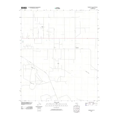
2010 Map of Seminole NE
USGS Topo · Published 2010About this map
Seminole East Oil Field and the Wescott Oil Field define the industrial footprint of this Gaines County landscape at the start of the 2010s. The region is characterized by a sprawling network of county roads, such as Co RD 104 and Ranch Rd 1429, that service the oil infrastructure and agricultural plots. The small settlement of Fairview sits as a primary junction in the northeast, connected to the surrounding territory by Fairview Rd. Natural drainage patterns are marked by the winding paths of Seminole Draw and Wardswell Draw, which cut through the otherwise orderly grid of rural routes. This topographic record highlights how energy extraction and ranching routes have integrated with the natural dry washes of the High Plains, providing a clear view of the area's development before more recent expansions.
Find a feature on this map
20 named features on this map. Tap any name to fly to it.
Don’t see what you’re looking for? This feature index may not catch every label — zoom into the map to look around manually.
Map Details
Editions of this 2010 Seminole NE Map
This is the sole edition of this map. No revisions or reprints were ever made.
Other maps of this area

1954 · Hobbs
USGS Topo · 1:250,000

1958 · Hobbs
USGS Topo · 1:250,000

1969 · Seminole SW
USGS Topo · 1:24,000

1970 · Seagraves SW
USGS Topo · 1:24,000

1970 · Seminole NE
USGS Topo · 1:24,000

1970 · Cedar Point Ranch
USGS Topo · 1:24,000

1970 · Seagraves SE
USGS Topo · 1:24,000

1970 · McKenzie Lake NW
USGS Topo · 1:24,000

1970 · Seminole SE
USGS Topo · 1:24,000
1970 · Loop SW
USGS Topo · 1:24,000