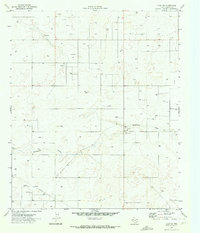
1970 Map of Loop SW
USGS Topo · Published 1973About this map
McKenzie Draw carves a subtle path across the Gaines County landscape, serving as the primary topographic feature in an area defined by mineral extraction and agriculture during the early 1970s. This survey, conducted by the Geological Survey in cooperation with the Texas Water Development Board, reveals a region deeply integrated into the energy economy. Numerous sites marked as Gas Well and Oil Well dot the terrain, connected by a prominent underground Pipeline. This industrial footprint is further evidenced by several Gravel Pits and a lone Gravel Pit positioned near the drainage. The map provides a precise look at the land's transition from open range to a managed resource landscape, showing the density of wells and the critical role of ephemeral watercourses in West Texas.
Find a feature on this map
6 named features on this map. Tap any name to fly to it.
Don’t see what you’re looking for? This feature index may not catch every label — zoom into the map to look around manually.
Map Details
Editions of this 1970 Loop SW Map
This is the sole edition of this map. No revisions or reprints were ever made.
Other maps of this area

1954 · Hobbs
USGS Topo · 1:250,000

1958 · Hobbs
USGS Topo · 1:250,000

1969 · Loop
USGS Topo · 1:24,000

1969 · Ashmore
USGS Topo · 1:24,000

1970 · Seminole NE
USGS Topo · 1:24,000

1970 · Seagraves SE
USGS Topo · 1:24,000

1970 · McKenzie Lake NW
USGS Topo · 1:24,000

1970 · Seagraves
USGS Topo · 1:24,000

1970 · McKenzie Lake
USGS Topo · 1:24,000
1970 · Cedar Point
USGS Topo · 1:24,000