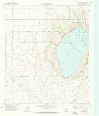
1970 Map of Cedar Point
USGS Topo · Published 1974About this map
Cedar Lake dominates this 1970s landscape on the Texas High Plains, revealing a specialized industrial and extractive economy. The shoreline is marked by the Cedar Lake Oil Field and the distinctive Cedar Point landform, while the lake itself is utilized for mineral production through a Salt Evaporator and several Wells (Salt). This map provides a detailed view of the resource-driven infrastructure common to Gaines County during this era, including a Chemical Plant and a Cotton Gin situated among a vast network of oil wells and a Drill Hole. The terrain is further defined by the winding path of Mc Kenzie Draw, illustrating the relationship between the area's arid natural drainage and its heavy industrial footprint. It is a revealing look at the rural industrialization that characterized the Permian Basin region in the mid-20th century.
Find a feature on this map
13 named features on this map. Tap any name to fly to it.
Don’t see what you’re looking for? This feature index may not catch every label — zoom into the map to look around manually.
Map Details
Editions of this 1970 Cedar Point Map
This is the sole edition of this map. No revisions or reprints were ever made.
Other maps of this area

1954 · Hobbs
USGS Topo · 1:250,000

1958 · Hobbs
USGS Topo · 1:250,000

1969 · Loop
USGS Topo · 1:24,000

1969 · Ashmore
USGS Topo · 1:24,000

1969 · Welch SW
USGS Topo · 1:24,000
1969 · Welch West
USGS Topo · 1:24,000

1970 · McKenzie Lake NW
USGS Topo · 1:24,000
1970 · Loop SW
USGS Topo · 1:24,000

1970 · Sand
USGS Topo · 1:24,000

1970 · McKenzie Lake
USGS Topo · 1:24,000