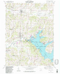
1994 Map of Senecaville
USGS Topo · Published 1998About this map
Senecaville Lake dominates the southern reaches of this Guernsey County landscape, held by the Senecaville Dam and managed by the Muskingum Watershed Conservancy District. The map reveals a complex land division history, showing the South Boundary Congress Lands meeting the Military District near the Senecaville National Fish Hatchery. The northern portion of the quadrangle is defined by the Leatherwood Creek valley, where the Baltimore and Ohio railroad corridor connects Lore City and Gibson.
Find a feature on this map
49 named features on this map. Tap any name to fly to it.
Don’t see what you’re looking for? This feature index may not catch every label — zoom into the map to look around manually.
Map Details
Editions of this 1994 Senecaville Map
This is the sole edition of this map. No revisions or reprints were ever made.
Other maps of this area

1909 · Antrim
USGS Topo · 1:48,000

1909 · Summerfield
USGS Topo · 1:62,500

1909 · Cambridge
USGS Topo · 1:62,500

1911 · Antrim
USGS Topo · 1:62,500

1911 · Cumberland
USGS Topo · 1:62,500

1911 · Summerfield
USGS Topo · 1:62,500

1912 · Cambridge
USGS Topo · 1:62,500

1949 · Clarksburg
USGS Topo · 1:250,000

1951 · Canton
USGS Topo · 1:250,000

1953 · Canton
USGS Topo · 1:250,000