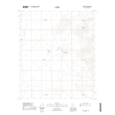
2020 Map of Sentinel Butte
USGS Topo · Published 2020About this map
Alamo Hueco serves as a central reference point in this arid landscape of southern Hidalgo County, where the desert floor of the Playas Valley meet the rising elevations of the Alamo Hueco Mountains. This 2020 survey illustrates a region defined by its drainage patterns and vertical topography, centered on the distinctive profile of Sentinel Butte. The terrain is deeply incised by seasonal waterways such as Bear Cr, Bull Cr, and Willow Cr, which flow from the higher reaches of Black Canyon and Wood Canyon. These geographical features dictate the path of the few established thoroughfares, notably Alamo Hueco Rd, which traverses the center of the quadrangle. The map provides a precise view of the Public Land Survey System divisions, documenting the township and range boundaries that organize this remote New Mexico borderland.
Find a feature on this map
17 named features on this map. Tap any name to fly to it.
Don’t see what you’re looking for? This feature index may not catch every label — zoom into the map to look around manually.
Map Details
Editions of this 2020 Sentinel Butte Map
This is the sole edition of this map. No revisions or reprints were ever made.
Other maps of this area

1917 · Antelope Wells
USGS Topo · 1:62,500

1918 · Big Hatchet Peak
USGS Topo · 1:62,500

1918 · Dog Mountains
USGS Topo · 1:62,500

1918 · Walnut Wells
USGS Topo · 1:62,500

1919 · Antelope Wells
USGS Topo · 1:62,500

1923 · Walnut Wells
USGS Topo · 1:62,500

1955 · Douglas
USGS Topo · 1:250,000

1959 · Douglas
USGS Topo · 1:250,000

1961 · Douglas
USGS Topo · 1:250,000

1964 · Douglas
USGS Topo · 1:250,000