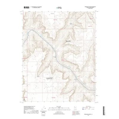
2018 Map of Separation Canyon
USGS Topo · Published 2018About this map
The Colorado River cuts a deep path through the Lower Granite Gorge in this Mohave County landscape, where the waters are marked by a series of significant river features. Navigational challenges for river runners and historians are noted by the sequence of named white water, including Two Hundred and Fortyone Mile Rapids, the well-known Separation Rapids, and Gneiss Canyon Rapids. The terrain transitions from the high elevations of the Sanup Plateau in the north down into the canyons that define the border between Grand Canyon National Park and the Lake Mead National Recreation Area. Numerous deep drainages converge with the main river channel, most notably Separation Canyon and Bridge Canyon, providing a clear record of the complex geological drainage patterns in this corner of Arizona as they appeared in 2018.
Find a feature on this map
24 named features on this map. Tap any name to fly to it.
Don’t see what you’re looking for? This feature index may not catch every label — zoom into the map to look around manually.
Map Details
Editions of this 2018 Separation Canyon Map
This is the sole edition of this map. No revisions or reprints were ever made.
Other maps of this area

1886 · Diamond Creek
USGS Topo · 1:250,000

1892 · Diamond Creek
USGS Topo · 1:250,000

1948 · Williams
USGS Topo · 1:250,000

1954 · Williams
USGS Topo · 1:250,000

1956 · Williams
USGS Topo · 1:250,000

1960 · Williams
USGS Topo · 1:250,000

1961 · Williams
USGS Topo · 1:250,000
1967 · Milkweed Canyon NW
USGS Topo · 1:24,000
1967 · Travertine Rapids
USGS Topo · 1:24,000
1967 · Peach Springs Canyon
USGS Topo · 1:24,000