
1934 Map of Seven Pines
USGS Topo · Published 1934About this map
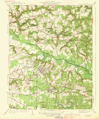
Chickahominy River bisects this landscape of central Virginia, where the legacy of the Civil War remains deeply etched into the topography. The 1930s survey documents a region transitioning from its 19th-century battlefield identity to a modern aviation and transit hub. To the north, the historic sites of Old Cold Harbor and New Cold Harbor are marked by the National Cem and the Watt House, while the Gaines Mill area sits near the winding Beaverdam Creek. The southern half of the map reveals the growth of Highland Springs and Sandston along the Southern Railway. A defining modern landmark is the Richard E Byrd Landing Field, accompanied by a Radio Station WNR and Radio Range Beacon, signifying the early development of Richmond’s air infrastructure. These layers of history sit atop a dense network of country schools like Dry Bridge Sch and local landmarks such as Simpkins Store.
Find a feature on this map
41 named features on this map. Tap any name to fly to it.
Don’t see what you’re looking for? This feature index may not catch every label — zoom into the map to look around manually.
Map Details
Editions of this 1934 Seven Pines Map
This is the sole edition of this map. No revisions or reprints were ever made.
Other maps of this area

1894 · Bermuda Hundred
USGS Topo · 1:62,500

1894 · Richmond
USGS Topo · 1:62,500

1895 · Richmond
USGS Topo · 1:62,500

1918 · Charles City
USGS Topo · 1:62,500

1920 · King William
USGS Topo · 1:62,500

1934 · Richmond
USGS Topo · 1:24,000

1938 · Dutch Gap
USGS Topo · 1:24,000
1938 · Seven Pines
USGS Topo · 1:31,680

1938 · Drewrys Bluff
USGS Topo · 1:24,000
1938 · Studley
USGS Topo · 1:31,680