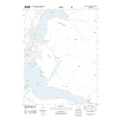
2011 Map of Shadow Mountain
USGS Topo · Published 2011About this map
The Colorado River defines the high-altitude landscape of this 2011 survey, feeding a complex system of water management and recreation at the edge of Rocky Mountain National Park. Central to the area are the connected waters of Grand Lake, Shadow Mountain Lake, and the expansive Lake Granby, linked by engineering features like the Granby Pump Canal and the Shadow Mountain Dam. These reservoirs are flanked by prominent peaks including Shadow Mountain, Mount Wescott, and Mount Acoma, while historical irrigation efforts are represented by the Lehman Ditch and Never Summer Ditch. Public access to the shoreline is well-documented through numerous sites such as Arapaho Bay, Columbine Bay Campground, and the Sunset Point Boat Ramp. The presence of the West Portal and various islands like Deer Island and Elephant Island highlights the dual nature of the region as both a critical watershed and a primary destination for mountain recreation.
Find a feature on this map
73 named features on this map. Tap any name to fly to it.
Don’t see what you’re looking for? This feature index may not catch every label — zoom into the map to look around manually.
Map Details
Editions of this 2011 Shadow Mountain Map
This is the sole edition of this map. No revisions or reprints were ever made.
Other maps of this area

1915 · Longs Peak
USGS Topo · 1:125,000

1919 · Rocky Mountain National Park
USGS Topo · 1:125,000

1954 · Greeley
USGS Topo · 1:250,000

1957 · Greeley
USGS Topo · 1:250,000

1957 · Mc Henrys Peak
USGS Topo · 1:24,000

1957 · Bowen Mountain
USGS Topo · 1:24,000
1957 · Trail Mountain
USGS Topo · 1:24,000
1957 · Granby
USGS Topo · 1:24,000

1958 · Greeley
USGS Topo · 1:250,000
1958 · Strawberry Lake
USGS Topo · 1:24,000