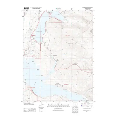
2013 Map of Shadow Mountain
USGS Topo · Published 2013About this map
Grand Lake and the interconnected waters of Shadow Mountain Lake and Lake Granby anchor this high-altitude landscape where the headwaters of the Colorado River meet complex water-management infrastructure. The 2013 survey documents the engineering of the Alva B Adams Tunnel and the Granby Pump Canal, which facilitate the trans-continental diversion of water through the West Portal. This alpine region is defined by its recreational and conservation footprint within Arapaho National Forest and Rocky Mountain National Park, featuring a dense network of trails and campsites. Long-distance hikers are served by the Continental Divide National Scenic Trail, while boaters and campers utilize facilities like the Hilltop Boat Ramp, Green Ridge Campground, and Pine Beach Area. Named peaks like Shadow Mountain and Mount Acoma rise above the series of bays and islands, including Elephant Island and Harvey Island, that characterize these mountain reservoirs.
Find a feature on this map
85 named features on this map. Tap any name to fly to it.
Don’t see what you’re looking for? This feature index may not catch every label — zoom into the map to look around manually.
Map Details
Editions of this 2013 Shadow Mountain Map
This is the sole edition of this map. No revisions or reprints were ever made.
Other maps of this area

1915 · Longs Peak
USGS Topo · 1:125,000

1919 · Rocky Mountain National Park
USGS Topo · 1:125,000

1954 · Greeley
USGS Topo · 1:250,000

1957 · Greeley
USGS Topo · 1:250,000

1957 · Mc Henrys Peak
USGS Topo · 1:24,000

1957 · Bowen Mountain
USGS Topo · 1:24,000
1957 · Trail Mountain
USGS Topo · 1:24,000
1957 · Granby
USGS Topo · 1:24,000

1958 · Greeley
USGS Topo · 1:250,000
1958 · Strawberry Lake
USGS Topo · 1:24,000