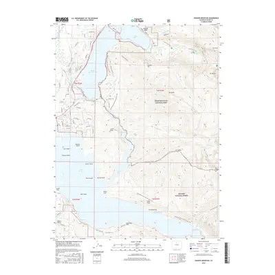
2016 Map of Shadow Mountain
USGS Topo · Published 2016About this map
Grand Lake serves as the gateway to this alpine landscape, where the waters of the Colorado River are managed through an intricate system of high-altitude engineering. The map details the proximity of Shadow Mountain Lake and the northern reaches of Lake Granby, illustrating how the Alva B Adams Tunnel and the Granby Pump Canal facilitate water movement across the continental shelf. These mid-century water projects reshaped the local geography, creating distinctive features like Rainbow Island, Gull Island, and Shelter Island within the newly formed reservoirs.
Find a feature on this map
92 named features on this map. Tap any name to fly to it.
Don’t see what you’re looking for? This feature index may not catch every label — zoom into the map to look around manually.
Map Details
Editions of this 2016 Shadow Mountain Map
This is the sole edition of this map. No revisions or reprints were ever made.
Other maps of this area

1915 · Longs Peak
USGS Topo · 1:125,000

1919 · Rocky Mountain National Park
USGS Topo · 1:125,000

1954 · Greeley
USGS Topo · 1:250,000

1957 · Greeley
USGS Topo · 1:250,000

1957 · Mc Henrys Peak
USGS Topo · 1:24,000

1957 · Bowen Mountain
USGS Topo · 1:24,000
1957 · Trail Mountain
USGS Topo · 1:24,000
1957 · Granby
USGS Topo · 1:24,000

1958 · Greeley
USGS Topo · 1:250,000
1958 · Strawberry Lake
USGS Topo · 1:24,000