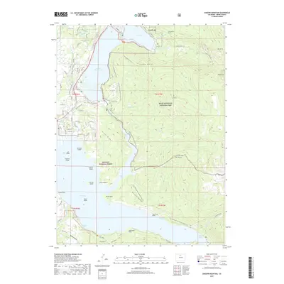
2019 Map of Shadow Mountain
USGS Topo · Published 2019About this map
Grand Lake serves as the gateway to this high-altitude landscape, where the waters of the Grand Lake and Shadow Mountain Lake meet in the Colorado Rockies. The map documents the intricate interface of water and land, showcasing the developed shoreline and the nearby Alpine environment. This 2019 survey provides a precise look at the modern layout of the town, illustrating how the community has integrated with the natural lakefront and surrounding topography. It serves as a vital record for understanding the contemporary footprint of this mountain settlement and its relationship with the vast protected lands that define its borders.
Find a feature on this map
1 named feature on this map. Tap any name to fly to it.
Don’t see what you’re looking for? This feature index may not catch every label — zoom into the map to look around manually.
Map Details
Editions of this 2019 Shadow Mountain Map
This is the sole edition of this map. No revisions or reprints were ever made.
Other maps of this area

1915 · Longs Peak
USGS Topo · 1:125,000

1919 · Rocky Mountain National Park
USGS Topo · 1:125,000

1954 · Greeley
USGS Topo · 1:250,000

1957 · Greeley
USGS Topo · 1:250,000

1957 · Mc Henrys Peak
USGS Topo · 1:24,000

1957 · Bowen Mountain
USGS Topo · 1:24,000
1957 · Trail Mountain
USGS Topo · 1:24,000
1957 · Granby
USGS Topo · 1:24,000

1958 · Greeley
USGS Topo · 1:250,000
1958 · Strawberry Lake
USGS Topo · 1:24,000