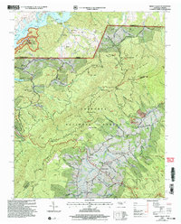
2003 Map of Shady Valley
USGS Topo · Published 2004About this map
Iron Mountains and the sprawling Jefferson National Forest dominate this landscape on the border of Tennessee and Virginia. The rural character of Denton Valley and the settlement of Shady Valley is preserved through a network of family-named landmarks and local institutions, including South Chapel and Denton Valley Ch. The mapping of cemetery sites like Montgomery Cem, Price Cem, and Blevins Cem offers significant value for genealogists tracing local families across county lines.
Find a feature on this map
132 named features on this map. Tap any name to fly to it.
Don’t see what you’re looking for? This feature index may not catch every label — zoom into the map to look around manually.
Map Details
Editions of this 2003 Shady Valley Map
This is the sole edition of this map. No revisions or reprints were ever made.
Other maps of this area

1891 · Roan Mountain
USGS Topo · 1:125,000

1891 · Abingdon
USGS Topo · 1:125,000

1893 · Cranberry
USGS Topo · 1:125,000

1894 · Roan Mountain
USGS Topo · 1:125,000

1894 · Abingdon
USGS Topo · 1:125,000

1895 · Cranberry
USGS Topo · 1:125,000

1897 · Bristol
USGS Topo · 1:125,000

1899 · Cranberry
USGS Topo · 1:125,000

1902 · Bristol
USGS Topo · 1:125,000

1902 · Cranberry
USGS Topo · 1:125,000