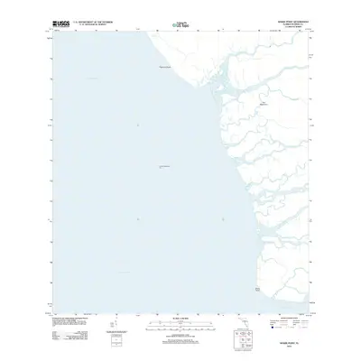
2012 Map of Shark Point
USGS Topo · Published 2012About this map
Shark Point and the complex tidal estuaries of the western Everglades define this coastline where the land dissolves into Ponce De Leon Bay and the Gulf of Mexico. The geography is a labyrinth of mangrove-lined waterways, including the winding Harney River, Broad River, and Rodgers River. This map shows a landscape nearly devoid of human infrastructure, save for the Broad Creek Light Six navigation aid, emphasizing the primitive hydrological character of the region. Distinctive features like the curiously named The Nightmare and the narrow stretch of Highland Beach illustrate the shifting boundary between limestone shelf, marshland, and open sea. For researchers, it provides a precise modern baseline of the coastal fringe near Graveyard Cr and Big Cr before further environmental changes or sea-level shifts alter these delicate subtropical drainage patterns.
Find a feature on this map
13 named features on this map. Tap any name to fly to it.
Don’t see what you’re looking for? This feature index may not catch every label — zoom into the map to look around manually.
Map Details
Editions of this 2012 Shark Point Map
This is the sole edition of this map. No revisions or reprints were ever made.
Other maps of this area

1956 · Miami
USGS Topo · 1:250,000

1958 · Miami
USGS Topo · 1:250,000

1972 · Whitewater Bay West
USGS Topo · 1:24,000

1972 · Harney River
USGS Topo · 1:24,000

1972 · Shark River Island
USGS Topo · 1:24,000

1972 · Shark Point
USGS Topo · 1:24,000
1973 · Plover Key
USGS Topo · 1:24,000

1973 · Big Lostmans Bay
USGS Topo · 1:24,000

1973 · Lostmans River Ranger Station
USGS Topo · 1:24,000

1981 · Cape Sable
USGS Topo · 1:100,000