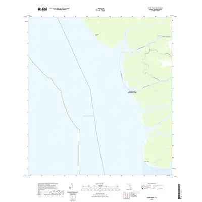
2021 Map of Shark Point
USGS Topo · Published 2021About this map
Shark Point and Highland Beach mark the western coastal edge of Monroe County where the freshwater systems of the interior meet the salt of the Gulf of Mexico. This coastal interface is defined by a dense network of tidal rivers and creeks, including the Harney River, Broad River, and the appropriately named The Nightmare. These waterways form the vital arteries of Everglades National Park, providing a sanctuary for diverse wildlife and a complex landscape for navigation. Modern recreational routes like the Wilderness Waterway Trl and the Everglades Paddling Trl follow these natural corridors, connecting Ponce de Leon Bay in the south toward the northern reaches of the Wilderness Waterway. The presence of Graveyard Creek hints at the challenges faced by early travelers in this labyrinthine environment of mangroves and sawgrass.
Find a feature on this map
17 named features on this map. Tap any name to fly to it.
Don’t see what you’re looking for? This feature index may not catch every label — zoom into the map to look around manually.
Map Details
Editions of this 2021 Shark Point Map
This is the sole edition of this map. No revisions or reprints were ever made.
Other maps of this area

1956 · Miami
USGS Topo · 1:250,000

1958 · Miami
USGS Topo · 1:250,000

1972 · Whitewater Bay West
USGS Topo · 1:24,000

1972 · Harney River
USGS Topo · 1:24,000

1972 · Shark River Island
USGS Topo · 1:24,000

1972 · Shark Point
USGS Topo · 1:24,000
1973 · Plover Key
USGS Topo · 1:24,000

1973 · Big Lostmans Bay
USGS Topo · 1:24,000

1973 · Lostmans River Ranger Station
USGS Topo · 1:24,000

1981 · Cape Sable
USGS Topo · 1:100,000