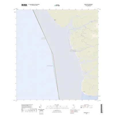
2024 Map of Shark Point
USGS Topo · Published 2024About this map
Shark Point and the coastal mangrove estuaries of Everglades National Park define this aquatic landscape where the freshwater of The Everglades meets the Gulf of Mexico. This modern topographic study reveals a complex network of tidal rivers and creeks, including the aptly named The Nightmare, which winds through the Marjory Stoneman Douglas Wilderness. The map highlights specialized transportation routes through the wetlands, such as the Wilderness Waterway Trl and the Everglades Paddling Trl, which navigate the labyrinthine passages of the Broad River and Rodgers River. From the narrow strip of Highland Beach to the southern opening of Ponce de Leon Bay, the map serves as a contemporary record of Florida's southwest coast, documenting the natural hydrologic patterns of Graveyard Creek and Wood River in a region largely devoid of permanent human settlements.
Find a feature on this map
16 named features on this map. Tap any name to fly to it.
Don’t see what you’re looking for? This feature index may not catch every label — zoom into the map to look around manually.
Map Details
Editions of this 2024 Shark Point Map
This is the sole edition of this map. No revisions or reprints were ever made.
Other maps of this area

1956 · Miami
USGS Topo · 1:250,000

1958 · Miami
USGS Topo · 1:250,000

1972 · Whitewater Bay West
USGS Topo · 1:24,000

1972 · Harney River
USGS Topo · 1:24,000

1972 · Shark River Island
USGS Topo · 1:24,000

1972 · Shark Point
USGS Topo · 1:24,000
1973 · Plover Key
USGS Topo · 1:24,000

1973 · Big Lostmans Bay
USGS Topo · 1:24,000

1973 · Lostmans River Ranger Station
USGS Topo · 1:24,000

1981 · Cape Sable
USGS Topo · 1:100,000