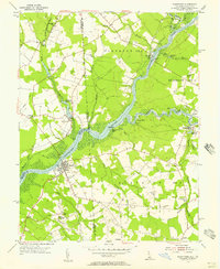
1955 Map of Sharptown
USGS Topo · Published 1957About this map
The Nanticoke River carves a winding path through the borderlands of Maryland and Delaware, anchoring a landscape defined by tidewater commerce and small-scale milling in the mid-1950s. The bustling river traffic of previous generations is evidenced by landings such as Baileys Landing and Hurts Wharf, while the Woodland Ferry continues to provide a vital link across the water. On the Maryland side, the town of Sharptown serves as a local hub, surrounded by smaller settlements like Santo Domingo and Columbia. Inland, the economy is clearly tied to the numerous millponds and branches that feed the river system, including Wrights Millpond and Galestown Millpond. Cultural life is marked by rural congregational centers such as Mt Pleasant Ch and Cokesbury Ch, many of which feature adjacent cemeteries that serve as essential records for genealogical research in this long-settled coastal plain.
Find a feature on this map
70 named features on this map. Tap any name to fly to it.
Don’t see what you’re looking for? This feature index may not catch every label — zoom into the map to look around manually.
Map Details
Editions of this 1955 Sharptown Map
2 editions found
Other maps of this area

1901 · Salisbury
USGS Topo · 1:62,500

1903 · Nanticoke
USGS Topo · 1:62,500

1905 · Hurlock
USGS Topo · 1:62,500

1915 · Seaford
USGS Topo · 1:62,500

1942 · Mardela Springs
USGS Topo · 1:24,000

1942 · Hebron
USGS Topo · 1:24,000

1942 · Delmar
USGS Topo · 1:24,000
1943 · Mardela Springs
USGS Topo · 1:31,680
1943 · Delmar
USGS Topo · 1:31,680

1943 · Hebron
USGS Topo · 1:31,680