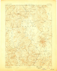
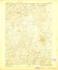
1886 Map of Shasta
USGS Topo · Published 1898About this map
Mt. Shasta and the high ridges of the Siskiyou Mountains dominate this reconnaissance-scale survey, which documents Northern California just before the turn of the century. The map captures a landscape defined by pioneer industry and transit, featuring early hydraulic infrastructure like the Yreka Irrigating Ditch and river crossings such as the Oak Bar Ferry. While Yreka serves as a primary hub, smaller mining and ranching outposts like Mugginsville, Oro Fino, and Callahan Ranch illustrate the dispersed nature of late 1800s settlement in Siskiyou. The inclusion of the Altoona Mines and Empire Mill alongside high mountain camps like Horse Camp and Wagon Camp reflects an economy balanced between resource extraction and the difficult logistics of the high Sierra Nevada and Cascade ranges.
Find a feature on this map
137 named features on this map. Tap any name to fly to it.
Don’t see what you’re looking for? This feature index may not catch every label — zoom into the map to look around manually.
Map Details
Editions of this 1886 Shasta Map
3 editions found
Other maps of this area

1886 · Lassen Peak
USGS Topo · 1:250,000

1886 · Modoc Lava Bed
USGS Topo · 1:250,000

1886 · Shasta
USGS Topo · 1:250,000

1889 · Klamath
USGS Topo · 1:250,000

1890 · Red Bluff
USGS Topo · 1:250,000

1891 · Ashland
USGS Topo · 1:250,000

1892 · Modoc Lava-Bed
USGS Topo · 1:250,000

1892 · Lassen Peak
USGS Topo · 1:250,000

1893 · Ashland
USGS Topo · 1:250,000

1894 · Lassen Peak
USGS Topo · 1:250,000