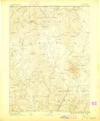
1886 Map of Shasta
USGS Topo · Published 1896About this map
The northern California landscape is dominated by the volcanic presence of Mt Shasta and its companion peak, Shastina, during this late nineteenth-century survey. The region displays a diverse frontier economy, where mining operations like the Altoona Mines and Empire Mill are established alongside a complex network of settlements. In the Siskiyou Valley, the Yreka Irrigating Ditch snakes through the terrain toward Yreka, illustrating early efforts to manage water for both gold processing and agriculture. Strategic transit points such as Henley and the Ferry near Round Hill facilitate movement across the rugged northern reaches near the Oregon California Boundary Line. From the military history of Fort Jones to the small-scale mining camps of Mugginsville and Oro Fino, the map documents the transitional period when remote mountain drainages like the South Fork Scott River were becoming hubs of industry and permanent residency.
Find a feature on this map
128 named features on this map. Tap any name to fly to it.
Don’t see what you’re looking for? This feature index may not catch every label — zoom into the map to look around manually.
Map Details
Editions of this 1886 Shasta Map
3 editions found
Other maps of this area

1886 · Lassen Peak
USGS Topo · 1:250,000

1886 · Modoc Lava Bed
USGS Topo · 1:250,000

1886 · Shasta
USGS Topo · 1:250,000

1889 · Klamath
USGS Topo · 1:250,000

1890 · Red Bluff
USGS Topo · 1:250,000

1891 · Ashland
USGS Topo · 1:250,000

1892 · Modoc Lava-Bed
USGS Topo · 1:250,000

1892 · Lassen Peak
USGS Topo · 1:250,000

1893 · Ashland
USGS Topo · 1:250,000

1894 · Lassen Peak
USGS Topo · 1:250,000