2022 Map of Sheboygan Falls
USGS Topo · Published 2022About this map
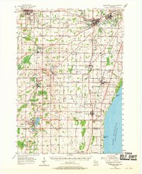
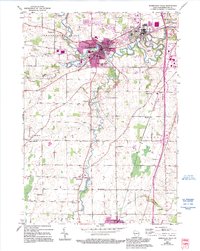
Sheboygan Falls sits at the confluence of the Sheboygan River and the Mullet River, serving as a central hub for this portion of Sheboygan County. The landscape is defined by the winding paths of the Onion River and Black River, which carve through the terrain near smaller settlements like Gibbsville and Weedens. This survey reveals a dense network of rural infrastructure, from the University of Wisconsin - Green Bay Sheboygan Campus in Kohler to numerous local burial grounds including the Jansen Cem and Flader Cem. The distribution of these sites, alongside the Saint George Catholic Cem and Blessed Trinity Parish Cem, suggests a long-established community structure where local faith and family history are deeply rooted in the farmland between Oostburg and the larger town centers.
Find a feature on this map
143 named features on this map. Tap any name to fly to it.
Don’t see what you’re looking for? This feature index may not catch every label — zoom into the map to look around manually.
Map Details
Editions of this 2022 Sheboygan Falls Map
This is the sole edition of this map. No revisions or reprints were ever made.
Historical Maps of Sheboygan Falls Through Time
3 maps found