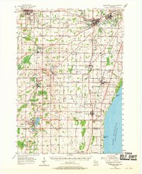
1954 Map of Sheboygan Falls
USGS Topo · Published 1970About this map
The Onion River and Sheboygan River dominate this Sheboygan County landscape as it appeared in the mid-1950s. The region is characterized by a high concentration of dairy-era rural infrastructure, with a dense network of country schools like River Valley Sch and Maple Grove Sch serving the farming townships. Industrial centers are well-established at Kohler and Sheboygan Falls, while the shoreline of Lake Michigan features small residential clusters such as Idlewood Beach.
Find a feature on this map
94 named features on this map. Tap any name to fly to it.
Don’t see what you’re looking for? This feature index may not catch every label — zoom into the map to look around manually.
Map Details
Editions of this 1954 Sheboygan Falls Map
2 editions found
Other maps of this area

1892 · Port Washington
USGS Topo · 1:62,500

1904 · West Bend
USGS Topo · 1:62,500

1904 · Port Washington
USGS Topo · 1:62,500

1954 · Sheboygan Falls
USGS Topo · 1:62,500

1954 · Sheboygan South
USGS Topo · 1:62,500

1954 · Sheboygan Falls
USGS Topo · 1:24,000

1954 · Sheboygan North
USGS Topo · 1:62,500

1954 · Sheboygan North
USGS Topo · 1:24,000

1954 · Sheboygan South
USGS Topo · 1:24,000

1954 · Howards Grove
USGS Topo · 1:62,500