
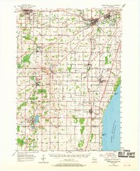
1954 Map of Sheboygan Falls
USGS Topo · Published 1956About this map
Lake Michigan forms the eastern edge of this mid-century landscape, where industrial towns like Plymouth, Sheboygan Falls, and Kohler anchor a complex network of dairy-land settlements. The topography is defined by glacial remnants such as the expansive Adell Swamp and the waters of Random Lake, while the Mullet River and Onion River wind through the countryside to power sites like the Waldo Mill Pond. This era captures a rural Wisconsin in transition, dotted with numerous one-room schoolhouses like Banner Sch and River Valley Sch, several of which, including Winooski Sch and Amsterdam Sch, are already noted as abandoned.
Find a feature on this map
117 named features on this map. Tap any name to fly to it.
Don’t see what you’re looking for? This feature index may not catch every label — zoom into the map to look around manually.
Map Details
Editions of this 1954 Sheboygan Falls Map
2 editions found
Other maps of this area

1892 · Port Washington
USGS Topo · 1:62,500

1904 · West Bend
USGS Topo · 1:62,500

1904 · Port Washington
USGS Topo · 1:62,500

1954 · Sheboygan South
USGS Topo · 1:62,500

1954 · Sheboygan Falls
USGS Topo · 1:24,000

1954 · Sheboygan North
USGS Topo · 1:62,500

1954 · Sheboygan North
USGS Topo · 1:24,000

1954 · Sheboygan South
USGS Topo · 1:24,000

1954 · Howards Grove
USGS Topo · 1:62,500

1954 · Howards Grove
USGS Topo · 1:24,000