
1943 Map of Shedd Canyon
USGS Topo · Published 1943About this map
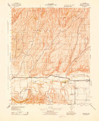
Huerhuero Rancho dominates the southern landscape of this 1943 survey, where family-named ranches and camps are scattered across the winding drainages of Huerhuero Creek. During the early war years, this region of San Luis Obispo County remained a remote patchwork of private holdings such as the Jackson & Reinhert Ranch and Upton Ranch, connected by the unpaved stretches of Creston Road and Shandon Road.
Find a feature on this map
32 named features on this map. Tap any name to fly to it.
Don’t see what you’re looking for? This feature index may not catch every label — zoom into the map to look around manually.
Map Details
Editions of this 1943 Shedd Canyon Map
This is the sole edition of this map. No revisions or reprints were ever made.
Other maps of this area

1897 · San Luis Obispo
USGS Topo · 1:62,500

1900 · San Luis
USGS Topo · 1:125,000

1914 · Cholame
USGS Topo · 1:125,000

1915 · Cholame
USGS Topo · 1:125,000

1917 · Cholame
USGS Topo · 1:125,000

1919 · Paso Robles
USGS Topo · 1:62,500

1922 · Pozo
USGS Topo · 1:62,500

1942 · San Luis Obispo
USGS Topo · 1:62,500
1943 · Shandon
USGS Topo · 1:31,680

1943 · Paso Robles
USGS Topo · 1:62,500