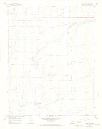
1967 Map of Sheds Camp
USGS Topo · Published 1971About this map
San Luis Maria Baca No 4, an expansive land grant in the high valley, defines the eastern portion of this 1960s landscape. The area is characterized by an extensive network of irrigation infrastructure designed to manage the waters flowing from the Sangre de Cristo range, including the Shellabarger Ditch No 2, Wales Travis Ditch, and the North Crestone Ditch. These diversions support a series of seasonal or ranching outposts such as Sheds Camp, Willow Camp, and Cottonwood Camp. Evidence of human activity is scattered across the flats, from the small settlement at Cartwright and the Landing Strip to numerous flowing wells that dot the drainages of San Luis Creek and Crestone Creek. The map documents a fragile balance of water rights and ranching in a region where creeks like Spanish Creek and Deadman Creek emerge from the mountains to feed the valley floor near Weisman Lake.
Find a feature on this map
22 named features on this map. Tap any name to fly to it.
Don’t see what you’re looking for? This feature index may not catch every label — zoom into the map to look around manually.
Map Details
Editions of this 1967 Sheds Camp Map
2 editions found
Other maps of this area

1954 · Trinidad
USGS Topo · 1:250,000

1954 · Pueblo
USGS Topo · 1:250,000

1955 · Trinidad
USGS Topo · 1:250,000

1957 · Pueblo
USGS Topo · 1:250,000

1958 · Trinidad
USGS Topo · 1:250,000

1958 · Pueblo
USGS Topo · 1:250,000

1959 · Trinidad
USGS Topo · 1:250,000

1959 · Electric Peak
USGS Topo · 1:62,500

1962 · Pueblo
USGS Topo · 1:250,000

1966 · Pueblo
USGS Topo · 1:250,000