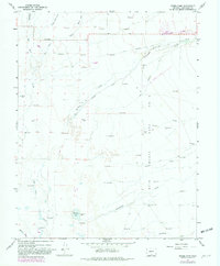
1967 Map of Sheds Camp
USGS Topo · Published 1982About this map
San Luis Creek and its many tributaries define this high-altitude landscape within the San Luis Valley during the late 1960s. The map illustrates a complex network of agricultural irrigation, featuring numerous ditches such as the Crestone Ditch and the Wales Travis Ditch. These systems support local ranching and settlement patterns near the town of Moffat, where the terrain begins its transition toward the eastern mountains. A significant portion of the area is occupied by the Luis Maria Baca No 4 land grant, a legacy of Spanish colonial history that influenced land use and property boundaries well into the modern era.
Find a feature on this map
25 named features on this map. Tap any name to fly to it.
Don’t see what you’re looking for? This feature index may not catch every label — zoom into the map to look around manually.
Map Details
Editions of this 1967 Sheds Camp Map
2 editions found
Other maps of this area

1954 · Trinidad
USGS Topo · 1:250,000

1954 · Pueblo
USGS Topo · 1:250,000

1955 · Trinidad
USGS Topo · 1:250,000

1957 · Pueblo
USGS Topo · 1:250,000

1958 · Trinidad
USGS Topo · 1:250,000

1958 · Pueblo
USGS Topo · 1:250,000

1959 · Trinidad
USGS Topo · 1:250,000

1959 · Electric Peak
USGS Topo · 1:62,500

1962 · Pueblo
USGS Topo · 1:250,000

1966 · Pueblo
USGS Topo · 1:250,000